Mt.
Carmel Fire - December 2010
The December 2010 fire on Mt.
Carmel tragically took 43 lives, most prison guard cadets whose bus was trapped by flames
as they made their way toward Damon Prison in an effort to evacuate inmates ahead of the
advancing blaze. Several years of drought and dense vegetation of pines, scrub oaks and
various maquis (or chapparal as we call it here in California) varieties, combined with
high winds (similar to California's santana winds that come in the fall) and steep
topography to create the massive inferno.
Jutting out into the sea, the
Carmel breaks Israel's nearly straight coastline, benefiting from the coastal fog and
additional rainfall due to its elevation. Its forests and heights gave it a regal quality
to the Biblical authors, useful for describing the head
of a royal lover or the coming
Babylonian juggernaut.
The dense vegetation there was
referenced by Isaiah as the "splendor
of Carmel" - a luxurious landcover in a country sitting on the edge of the
desert. Indeed, when God describes the restoration of Israel, it is Carmel's splendor that
will be bestowed on the barren wilderness. Carmel's loss of its splendor was a metaphor
for desperate times in the land.
Given Israel's repeated
attraction to Canaanite Baal worship, with its emphasis on controlling the rains and
fertility, it's not surprising Elijah
chose Carmel to challenge Jezebel's prophets of Baal. The traditional site of that contest where
Elijah called down fire from heaven is to the east of the present-day forest fire, but
it's modern Arabic name, Muhraqa, is still relevant - "the place of burning."
This Google Earth flight begins
in Haifa Bay and flies across the city and it's outlying communities that were threatened
if the fire had spread farther north. It then spirals across the burn area, although the
current Google Earth imagery pre-dates the fire - you'll see the landscape as it was.
The boundaries of the burn area are approximate and were made by overlaying a
low-resolution color-infrared image acquired when the fire was mostly contained and
tracing in the boundaries you see. The satellite image appears to be copyrighted, so I
won't post it - you can view
it here. Note - the satellite image is oriented north-up. My snapshot, below, from
Google Earth is oriented east-up.
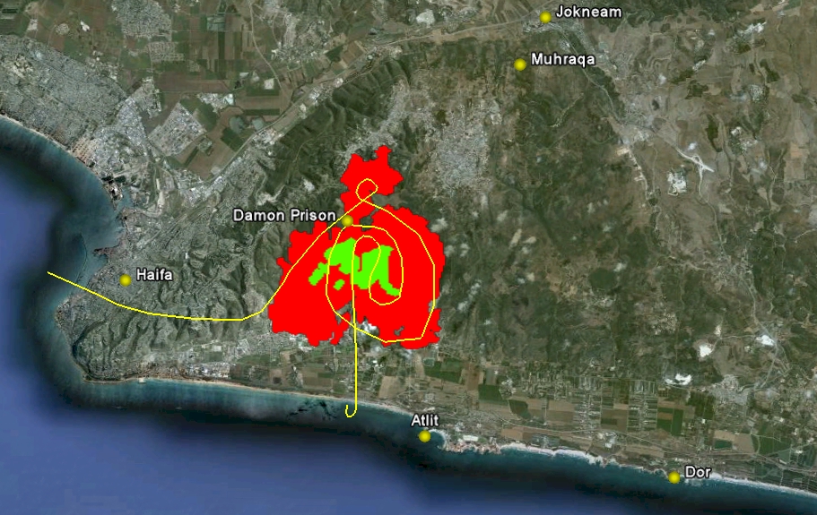
The area shown in red was nearly completely
burned. The green areas were spared, by and large, from the fire. In the flight, only the
red and green boundaries show. The burn area is primarily wildlands with no Biblical
connection of which I am aware.
The image, above, shows the setting on the
western slopes of Carmel where they meet the Plain of Dor. Dor was an important Caananite
seaport and its king
was one of 31 defeated by Joshua, although the Israelites
did not successfully dislodge the Caananites of Dor during the conquest. Later, one of
Solomon's son-in-laws (with 700 wives, who wasn't Solomon's son-in-law?)
lived here. Nearby Atlit was the
first place many crusaders set foot in the land during the Middle Ages - it was also the
last holdout abandoned by them in the long war with Islam.
Haifa is draped across the northwest tip of
Carmel. Its industrial port sits where the Kishon
River meets the Mediterranean. Follow the Kishon southwestward through the narrow pass
separating the hills of Lower Galilee from the Carmel Ridge until you reach Jokneam, the city protecting one
of the three major passes across Carmel. Its king was one of those defeated
by Joshua. Above Jokneam is Muhraqa, the traditional site of Elijah's
defeat of the prophets of Baal. Somewhere nearby, on the banks of the Kishon, he had
400 of Jezebel's
false prophets put to death.
On the immediate edge of the burned area is the
Damon Prison. It was here the busload of cadets were headed to evacuate prisoners when
they became trapped by the flames. It appears as though firefighters successfully stopped
the fire short of the prison walls.
Given the vegetation associations in this region
and the problem of insufficient rainfall, it's surprising such forest fires are not
mentioned in the long Biblical narrative. In the Gospels, we're told of sudden
storms on the Sea of Galilee that were likely the result of the type of winds that
fanned the Carmel fire. In David's battle with Absalom in the Gilead region, we're told "the
forest swallowed up more men that day than the sword" - perhaps a reference to
fires set by the two armies as part of their battle plan. Given the 2,000 or so years of
history the Bible chronicles here, big fires had to have occurred many, many times.
If you haven't done so yet, download the Google Earth plug-in. If you're
new to Google Earth, check the Flying
Tips & Tricks page.
Note: Sometimes
the place names do not display on the flight. The problem is intermittent and I have not
yet solved it. If you push the pause button, the place-name labels will then display.
Also, I recommend the use of Internet Explorer as your browser. Flights
are not viewable with Firefox. |