A
Closer Look at David and Goliath
The 17th
chapter of First Samuel gives us one of the best-known stories in the Bible - the
story of David and Goliath.
A shepherd boy is given a care
package of food to be taken to his brothers on the battlefield. He arrives at their
encampment to find the army of Israel and the army of the Philistines in a stalemate -
each side occupying opposite sides of a valley and no one willing to attack. The
Philistines have a tradition of settling military impasses by using champions - each side
puts its best fighter in the ring and winner takes all. They've brought a ringer - a giant
of a man named Goliath who's about 9-feet tall and who daily comes out to the battle line
and curses Israel's army and Israel's God.
Long story short, the
shepherd boy volunteers - to the jeers of his brother and misgivings of the king - and
uses the same sling to bring down the heavily armed giant he uses to chase off the wild
beasts who prey on his father's sheep. When he kills the fallen Goliath with the giant's
own sword, the Philistines flee in panic. The shepherd is the hero of the day, he gets the
princess and - after many hardships - becomes king.
But there's more to the story,
particularly for those with an eye for geographic detail. And this story has much more
geographic detail than most in the Bible.
We're told David's family lived
in Bethlehem. David's oldest brother, Eliab, greeted him with scorn when he
arrived at the camp, asking, "Why have you come down here? And with whom did
you leave those few sheep in the desert?" So, from the text, it's a safe bet
Bethlehem's either in or close to the desert and David traveled downhill from Bethlehem to
the battlefield. Both are true.
We're told quite a bit
about the battlefield as well. First of all, the enemy is Philistia, Israel's nemesis
living on the southern coastal plain between the sea and the foothills. Goliath is from
Gath, one of the five chief cities of the Philistines, and at the end of the story, when
the Philistines retreat in disarray, they flee "along the Shaaraim road to Gath and
Ekron," another of the five royal cities. Archaeologists believe they've identified
the locations of Gath and Ekron, so, we can place the battlefield between those cities and
Bethlehem. And there is an enticing new find that might identify the place the biblical
writer was referring to as Shaaraim.
Indeed, we're told much more. The
Philistines, ready for war, have assembled their troops at a city belonging to Judah
called Socoh. While Gath and Ekron are located where the coastal plain and western edge of
the foothills meet, Socoh is well to the east where the same foothills meet the base of
the mountains of Judah.
This foothill, or lowland, area
is called the Shephelah and is a geographic region unto itself. Over the centuries, it was
both security buffer and prize for Israel and Philistia. With Philistia now in possession
of Socoh, the buffer had been pierced. The invading army was now poised to ascend into the
heart of Judah along a ridge that climbed from the Shephelah to Bethlehem.
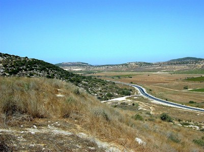 |
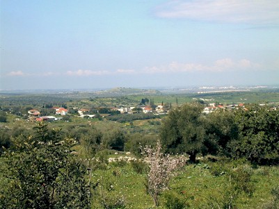
| View from Socoh across the Elah Valley to Azekah in the
distance, left. The Philistine battle line extended between the two cities along this
ridge on the south side of the valley. (Courtesy
BiblePlaces.com) |
Further, the Philistines
were in possession of Azekah, another major fortified Shephelah city. The Bible tells us
the Philistines were positioned between Socoh and Azekah. At a place between the two
cities called Ephes Dammim they set up their army encampment.
We know where Socoh and Azekah
were located. By examining the terrain, the Bible's account of the Philistine army's
strength and the response of Israel's army under King Saul, we can determine this was a
major military operation meant to either seize and hold the Shephelah or use it as the
jumping-off point for an invasion into the hill country of Judah.
Finally, we're told "Saul
and the Israelites assembled and camped in the Valley of Elah and drew up their battle
line to meet the Philistines. The Philistines occupied one hill and the Israelites
another, with the valley between them." This completes our picture of the
battlefield. Both Socoh and Azekah sit on ridges running along the southern edge of the
Valley of Elah. Another ridge, on the northern side, is the logical place to locate Saul's
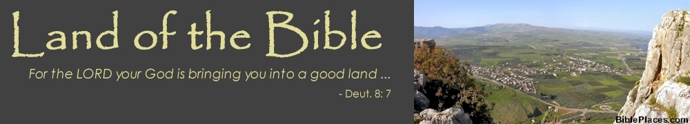
army. In the valley below, runs the Elah stream where David gathered five smooth stones
for his sling.
But where along the valley
floor did David and Goliath do battle? The answer to that question depends in large part
on how much of that ridge on the north side of the valley Saul controlled. As the bird
flies, the 2.6-mile line between Socoh and Azekah would give the western end of the ridge
to the Philistines. And given their position at Azekah and the reserves they could count
on from Gath and Ekron in their rear, it's reasonable to believe they had captured at
least a portion of the ridge - they had already shown themselves strong enough to push
forward to Socoh. On the other hand, the stream in the valley seems to have defined the
no-man's land between the two armies. Were both armies on the same side of the stream or
occupying the northern ridge, what feature formed the no-man's land? What kept two
motivated armies from clashing if not the stream? David is able to approach it unmolested
to pick his stones. Only after doing so does he make his approach toward Goliath and the
Philistine line.
Further, a relatively new
archaeological site, Khirbet Qaifeh, located near the western end of the northern ridge,
has been identified as a fortified Israelite city from the time of David. Was it also
overrun by the Philistines or did it hold out, allowing Saul to maintain his line of
defense all along the Elah Valley to the foot of Azekah? The less of the northern ridge in
Saul's hand, the greater the likelihood David and Goliath met toward the east end of the
valley. If Khirbet Qaifeh remained in Israel's hands, a better case can be made for the
battle of champions to have occurred at its western end where, I believe, the best
case can be made for the location of Ephes Dammim, the site of the Philistine army's
encampment.
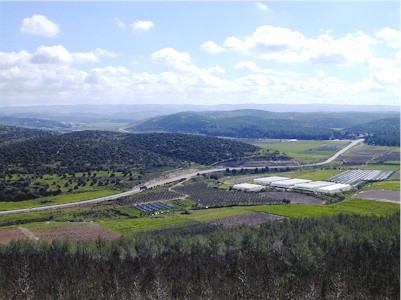 |
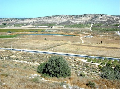
| Valley of Elah, looking southeast from
Azekah. Khirbet Qaifeh is just off the left of the image on the northern ridge in the
midground. The ridge beyond it, on the right, is the southern ridge occupied by the
Philistines. Socoh is located at the left end of the southern ridge, where it meets the
valley floor. The Philistine encampment at Ephes Dammim best fits the valley floor just
off the right of the image, in my opinion. In the far distance are the mountains of Judah.
(Courtesy
BiblePlaces.com) |
And Khirbet Qaifeh? The
archaeologist conducting the dig has claimed to have found two gates in the city wall - an
uncommon feature that links it to "the Shaaraim road to Gath and Ekron."
Shaaraim means "two gates."
Further reading:
The Valley of Elah
Azekah: Let's scan the battlefield from the Philistine camp
Biblical City Where David Battled Goliath Found?
Khirbet Kheyafa in Valley of Elah
Khirbet Qeiyafa excavation blog
Is Khirbet Qeiyafa Ephes Dammim?
Qeiyafa: Is it biblical Shaaraim?
Gath excavation blog
Enough talk - let's fly.
Click the play button on the image below to begin the flight from Bethlehem to the Valley
of Elah. The commentary to the right of the image is keyed to the time coding of the
flight. This flight takes just over 17 minutes. If that's too slow for your taste, click
on the fast-forward button on the control bar; each click doubles the speed.
Note: Sometimes
place names do not display on flights. The problem is intermittent and I have not yet
solved it. If you push the pause button, the place-name labels will then display. Also, I
recommend the use of Internet Explorer as your browser. Flights are not viewable with
Firefox.
|